Sunday, December 1, 2013

Hike #46 - Piestewa Peak Freedom (Circumference) Trail, Phoenix, AZ

November 30, 2013 was a perfect day for a hike with my friends from 24 Hour Fitness, Body Pump Class.  We started the Freedom (Circumference Trail) at 9 a.m.. The first 1/2 mile of this 4 mile loop is a strenuous climb up the first part of the Summit Trail which is the most crowded.  Once we diverted on to the Freedom Trail, there were much less people and the trail flattened out with some occasional gradual climb areas. It was so peaceful, it's hard to believe you are in the middle Arizona's largest metropolitan areas - Phoenix!  The trail is 3.6 miles but we walked there from a home in the area which added at least another mile.  The trail is abundant with Saguaro, ocotillo, prickly pear, cholla, brittle bush etc.  This trail is a great alternative to the overcrowded Summit Trail and I will definitely be doing it again.


Hike #45 - Kiwanis Trail, South Mountain Park, Phoenix, AZ

The Kiwanis Trail was built by the Phoenix Kiwanis Club and is one of the most popular trails at South Mountain Park.  Like most trails in the park, you are surrounded by beautiful Saguaros that are only found in the Sonoran Desert as well as a variety of other cacti.  The trail is one mile each way with an elevation gain of 480'.  Kiwanis Trail intersects Telegraph Pass Trail and National Trail. There are 2 rock wall dams built by the Civilian Conservation Corps in the 1930's. We passed several families with young children as it makes for a great adventure for the entire family.


Hike #44 - Holbert Trail, South Mountain Park, Phoenix, AZ

I have really enjoyed getting familiar with the trails in South Mountain Park in Phoenix this year.  The Holbert Trail is a popular trail and easy to get to with plenty of parking.  Round trip, the trail is 4.7 miles and you can easily add another mile if you take the Dobbins Trail at the intersection near the top to the popular scenic overlook.  I had driven to this spot several times in the past.  This particular Sunday was "Quiet Sunday" so no motorized vehicles were allowed. The elevation gain is approx. 1,100' and it took us approx. 3 hours with a long break at the top to enjoy the view.  There are some amazing petroglyphs along this trail. 


Wednesday, October 30, 2013

Hike #43 - Telegraph Pass Trail - South Mountain Park, Phoenix, AZ

Telegraph Pass Lookout
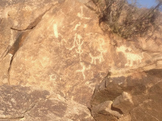
Paul and I hiked this trail on my birthday, October 27, 2013. Telegraph Pass Trail is a short and fairly easy hike with spectacular views of Ahwatukee and South Phoenix.  This is a popular trail so expect to pass lots of people.  The trail has an elevation gain of 500' and the distance is 2.3 miles RT. We extended the hike by continuing left on Summit Road and up to Telegraph Pass Lookout .25 miles, then continued on the Pyramid Trail another mile or so.  We hiked in late afternoon and appreciated the shade as we hiked up the East side.  The trail starts out as a wheelchair accessible paved path which continues around the neighborhood. After .4 miles there is a sign for Telegraph Pass Trail. Shortly after starting on the trail we passed Hohokam petroglyphs that are dated about 600 years old.
As with most AZ desert hikes, this trail comes alive in the Spring with wildflowers.  We saw many cacti including; cholla, saguaro, barrel cactus, hedgehog, ocotillo.
 
Saguaro


Hedgehog cactus


Cholla

Petroglyphs

Hike #42 - Alta Trail - South Mountain Park, Phoenix, AZ

South Mountain Park in Phoenix, AZ offers a variety of trails for hiking, mountain biking and horseback riding. The Alta Trail is a moderate hike of approx. 4 miles RT starting off of San Juan Road.  The trail has an elevation gain of approx. 1100'.  It is best to hike in the Spring or Fall when the temperatures in Phoenix are cooler or early morning in the summer.  Paul and I hiked the first week of October during the week and there were few people. We were limited on time so we did not continue on to the Bajada Loop or National Trail but these are options we may try in the future making for a longer hike.  This hike offers impressive views of South Phoenix, downtown Phoenix and South Mountain Park.  Parking is limited to only 5 cars so it is best to go at an off peak time.  


Monday, September 2, 2013

Hike #41 - Jerome Hill Climb, Jerome, AZ

This unique event is a 4.5 mile uphill run on paved and dirt roads that begins at the Jerome Historical Museum and passes through historic downtown Jerome, past the Gold King Mine before finishing on a nearby mountain top with gorgeous views of Sedona.  
This was a challenging run/hike but a lot of fun.  Most people walk a good portion of this due to the steep hills. Approx. 250 people attended, September 1, 2013.


Hike #40 - Long Canyon, Sedona, AZ

We hiked this trail the end of August, the day after a downpour in Sedona.   The forest was damp with the fragrant scent of pine everywhere. The ground was soft as we walked on a carpet of leaves and pine needles. The low hanging clouds hugged Maroon Mountain to our right and we couldn't stop taking photos every few steps. We followed the old jeep road for the first mile.  In the distance we could hear a flute.  As we drew closer, the gentleman playing the flute called to us from a rock above the trail and invited us up to see the view and feel the cool breeze.  We were glad we accepted his invitation as he was quite knowledgeable about the area. Another forest volunteer recommended a side hike from there to a slick rock area where we found several cave like areas that looked like Indian ruins. The Long Canyon trail is approx. 7 miles RT with an elevation gain of 828'.


Hike #39 - Alberta Falls Trail, Rocky Mountain National Park, CO

Alberta Falls
The moderate level trail to Alberta Falls is 1.4 miles out and back. There are semi-steep hills but the total elevation gain is only 160'. It is one of the most popular and crowded trails in the park.  We hiked this trail after hiking around Bear Lake.  The waterfall roars through a granite chute with huge rock slabs scattered around to sit and enjoy the beauty and sound of the water.  The trail passes through aspen groves then into pine forest.


Bull Elk - Near entrance to RMNP


Hike #38 - Bear Lake, Rocky Mountain National Park, CO

Long's Peak in the background. We hiked there the day prior.
       Bear Lake in Rocky Mountain National Park is one of the most popular places to visit in the park.  The half mile trail around the perimeter of the lake is easy and enjoyable for families.  The lake sits at 9,450' and was formed from a glacier.  There were endless photo opportunities around this lake.  We arrived early before the crowds and had no trouble finding a parking place.